12 GRAY BIRCH RD
Owner Information
PAOLINI JASON J
12 GRAY BIRCH RD
ASHLAND, MA 01721


Property Details
12 GRAY BIRCH RD is classified as a Single Family Residential (Cp).
The primary structure on this property was built in 1950. There are 1,664ft2 of built area within this property. There is 2,804ft2 of residential/living space within this property. This property is listed as having 7 rooms.
12 GRAY BIRCH RD is valued at $476,300. The land is valued at $215,500 and the structures are valued at $260,800. There is an additional valuation of $1,190 on this property.
This property is in Zone R1. Confirm with local Zoning Board authorities to ensure there are no overlays or other easements on this property.
The most recent deed for 12 GRAY BIRCH RD is recorded at the local registrar in Book 1212, Page 154. 12 GRAY BIRCH RD was last sold on Wednesday, October 20, 1999 for $159,800.
Assessment data from fiscal year 2022.
Flood Data
According to the FEMA National Flood Hazard Layer, this property does not appear to be in a flood zone. It may also be in an area not yet reviewed. Nonetheless, confirm this information prior to taking any action.
To view the flood hazards around this property, create a FEMA "Firmette" Map of the area around 12 GRAY BIRCH RD.
Broadband Internet Providers
| Provider | Type | Bandwidth (mbps) | |
|---|---|---|---|
| Viasat Inc | Satellite | 100 | 3 |
| VSAT Systems, LLC. | Satellite | 2 | 1 |
| HughesNet | Satellite | 25 | 3 |
| GCI Communication Corp. | Satellite | 0 | 0 |
| T-Mobile | Fixed Wireless | 25 | 3 |
| Comcast | Cable | 1000 | 35 |
| Verizon New England Inc. | Fiber | 940 | 880 |
Broadband service provider data from December 2020.
Adjacent Properties
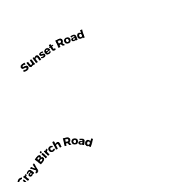
- 8 GRAY BIRCH RD
Single Family Residential owned by DESIATA DENNIS JR - 0 GRAY BIRCH RD
Undevelopable Residential Land owned by DESIATA DENNIS JR - 11 SUNSET RD
Single Family Residential owned by MURI JOSE - 15 SUNSET RD
Single Family Residential owned by MEADE MATTHEW S - 16 GRAY BIRCH RD
Single Family Residential owned by BENCH STEVEN C